A gray smear across the Willamette Valley and a green dot over your street can both be telling the truth at the same time. I learned that during a bad fire week, staring at circles, shading, and flame icons and wondering which one should change my afternoon plans. If you live in or travel through Oregon, you have probably had the same moment.
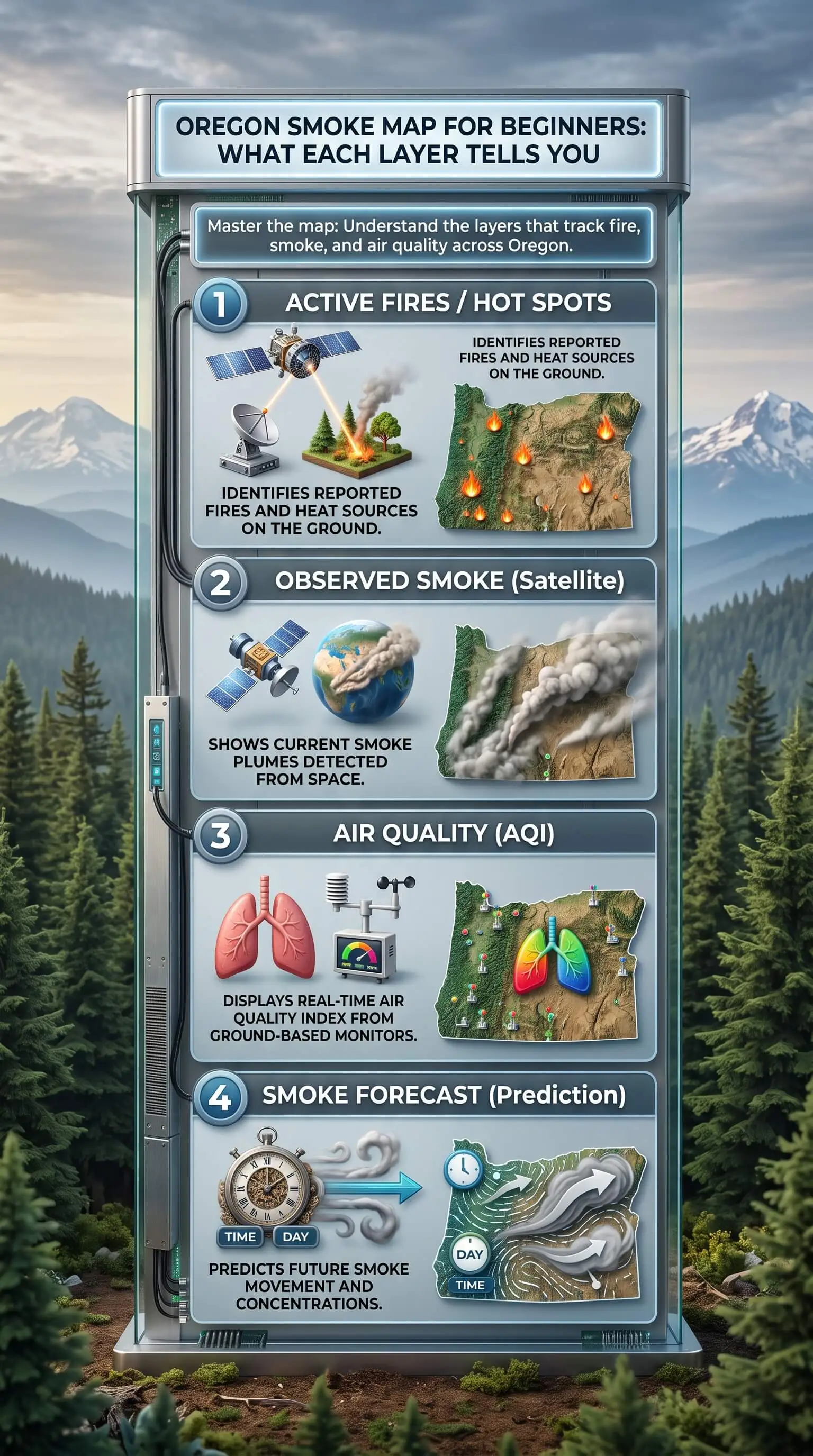
The smoke map Oregon residents lean on most, the AirNow Fire and Smoke Map, stacks four kinds of information on one screen: air quality at ground level, smoke plumes seen by satellite, fire locations, and forecast alerts. Each layer answers its own question. Once you know which, the map starts making sense.
TL;DR Quick Answers
Smoke Map Oregon
The smoke map Oregon residents rely on most is the AirNow Fire and Smoke Map, which layers ground-level air quality circles, satellite smoke plumes, fire icons, and forecast outlooks. For health decisions, trust the colored circle nearest you rather than the gray plume shading, since plumes often show smoke drifting high above breathing level.
Where to look: Start with the AirNow Fire and Smoke Map. Use Oregon DEQ's AQI page and the OregonAIR app for official advisories, and the Oregon Smoke Information Blog for tomorrow's forecast.
Circles: These show ground-level AQI. At orange, 101 and up, sensitive groups should limit time outside. At red, 151 and up, everyone should.
Plumes: The map hides these by default, so switch on "NOAA Smoke Plumes" in settings. Analysts update them about twice daily and can't see smoke at night or through clouds.
Oregon quirks: East winds through the Columbia River Gorge push smoke toward Portland. Overnight inversions trap smoke in the Willamette, Umpqua, and Rogue valleys until late morning.
Inside your home: Close up the house, flip the fan to "On," run MERV 11 filter if your system allows it, and add a HEPA air cleaner. A UV light won't remove smoke particles.
Top Takeaways
• Circles drive health decisions. Their color shows AQI at ground level.
• Plumes give context. They show smoke overhead and can miss it at night or under clouds.
• Flame icons show sources. Reported incidents include prescribed burns.
• Oregon terrain matters. Gorge winds and valley inversions can make your local air worse than the plume layer suggests.
• Indoor air needs filtration. Recirculate, run the fan, use MERV 13 where your system allows it, and skip counting on a UV light.
Which Oregon Smoke Map Should You Open First?
Each free tool has a job, and matching it to your question saves a lot of second-guessing.
• AirNow Fire and Smoke Map: The EPA and the U.S. Forest Service run this one. It pulls monitors, corrected low-cost sensors, fire locations, and satellite plumes into one view, which is why I open it first.
• Oregon DEQ Air Quality Index and the OregonAIR app: You get the state's official readings and advisories here, and the app can send notifications about air quality where you live.
• Oregon Smoke Information Blog: DEQ and partner agencies post daily forecasts and advisories here, so check it when you want to know what tomorrow looks like.
The Layers, One at a Time
Air Quality Circles: The Air You Breathe
Start with the circles, because they measure air at the height your family breathes. On the current AirNow map, circle size tells you what is measuring. A large circle with a number is a permanent monitor. Medium circles marked with a "T" are temporary monitors that agencies set up for fire events. The small blank ones are sensors.
Color gives you the AQI category. Green covers Good, 0 to 50. Yellow is Moderate at 51 to 100, and orange is Unhealthy for Sensitive Groups at 101 to 150. Red is Unhealthy at 151 to 200, purple is Very Unhealthy at 201 to 300, and maroon means Hazardous at 301 and up.
Tap any circle for current conditions, recommended actions, the day's history, and a trend marker that shows whether the air is improving or getting worse. Here's something that might surprise you: some Oregon pages that embed the map note that the number in a popup is a PM2.5 concentration, not an AQI value. Check the label before comparing tools.
Smoke Plumes: What Is Overhead
The map hides plumes by default. Tap the settings icon in the upper right and switch on "NOAA Smoke Plumes." That gray shading comes from NOAA's Hazard Mapping System, where trained analysts outline smoke on satellite images and label it light, medium, or heavy.
Analysts can't see smoke at night or through clouds. Their first daily analysis usually lands around 8 to 9 a.m. Pacific time, and a second update follows around 4 to 5 p.m. A plume only tells you smoke sits somewhere above you, maybe not at breathing height, so let the circles make your health calls.
Fire Icons: Reported Incidents vs. Satellite Detections
Flame icons mark fire incidents reported to the National Interagency Fire Center, including prescribed burns. Zoom in and you may spot the fire's perimeter outlined in brown. A light blue box around an incident means a Smoke Outlook covers that area. Glowing circles are satellite heat detections. Their positions are approximate.
Some trackers add toggles for new fires, prescribed fires, and potential detections. All of them point to where smoke started, and none can tell you what is in the air at your house.
Outlooks, Watches, and Warnings: What Is Coming
Forecast layers look ahead instead of reporting what is happening now. Air resource advisors write Smoke Outlooks for large fires, and each one covers the next several days. National Weather Service watches and warnings flag fire weather like strong wind and low humidity. Use them for planning, and the circles for right now.
When the Map and the Sky Disagree
Most beginner confusion comes from the map and the window telling two different stories.
• A heavy plume sits over green circles. The smoke is riding high. Trust the circles, and watch the trend marker through the day, because smoke aloft can mix down as the afternoon warms.
• You smell smoke, but the map shows no plume. Darkness, cloud cover, or smoke trapped low can hide it from the satellite. Check your nearest circle and the local advisory.
• The morning haze clears by noon. That's a classic valley inversion. Cool air near the ground holds smoke overnight until sunlight stirs the layers in late morning.
How Oregon Terrain Changes What You See
• Columbia River Gorge: East winds can push smoke west through the Gorge toward Hood River, Portland, and the north Willamette Valley, even from distant fires.
• Willamette, Umpqua, and Rogue valleys: Overnight inversions pin smoke close to the ground, so morning readings often look worse than afternoon ones.
• Central Oregon: Wildfire and prescribed burn smoke both drift through here, so tap the nearest flame icon to check for a planned burn before assuming the worst.
• Imported smoke: Lane County's air agency points out that smoke can blow in from California, Washington, Idaho, and even across the Pacific Ocean. Zoom out before you trust a clean local view.
What the Colors Mean for the Air Inside Your Home
Don't take your indoor air for granted when the map turns orange! Those colors describe outdoor air, but fine particles slip inside through gaps and fresh-air intakes. Once nearby circles hit orange, anyone in a sensitive group should cut back on time outdoors. At red and above, that goes for everyone. Here's exactly what to do inside:
1. Close windows and doors, then shut any fresh-air intake so your system recirculates the air already inside.
2. Flip the thermostat fan from "Auto" to "On" to keep air moving through the filter.
3. Run a filter rated MERV 13, or the highest efficiency your system can handle.
4. Put a portable HEPA air cleaner in the room you use most with a smoke CADR of at least two-thirds of its square footage.
5. Check the filter often during smoke events, and swap it out once it looks gray or airflow drops.
Pro Tip: If your system has a UV light, know what it's there for. UV-C lamps go after microbes on the coil and in passing air, but they don't catch particles. The EPA's indoor air filtration fact sheet lists devices with UV light components among technologies it doesn't recommend for smoke removal, since they aren't designed to remove particles. Let the filter handle the smoke.
"In my years reading smoke data through Oregon fire seasons, I've watched Willamette Valley monitors jump from yellow to red on inversion mornings before the first satellite analysis even posts. So I tell people the gray plume is the weather story, and the colored circle nearest your home is the health story."
7 Essential Resources
1. Live Oregon Wildfire and Smoke Map: Statewide fire, smoke, and warning layers, plus indoor smoke tips.
2. Oregon DEQ Fire and Air Quality Map: The state's embedded map, with notes on icons and popup numbers.
3. AirNow: How To Use the Fire and Smoke Map: The official walkthrough for circles, fire icons, plumes, and the trend marker.
4. NOAA Hazard Mapping System Fire and Smoke Product: Where the satellite plume layer comes from, with update timing and limits.
5. Oregon Health Authority: Wildfires and Smoke: At-risk group guidance, respirator tips, and fact sheets in 12 languages.
6. Lane Regional Air Protection Agency: Wildfire Smoke: Lane County smoke sources, mask advice, and a box fan filter how-to.
7. Central Oregon Fire Information: Smoke and Air Quality: Regional maps, AQI health levels, and fire text alerts.
3 Supporting Statistics
1. An EPA working paper found that on roughly 43% of county-days with a heavy smoke plume overhead, estimated smoke PM2.5 at the surface stayed below 5 µg/m³. EPA National Center for Environmental Economics
2. A 2025 review hosted by the National Library of Medicine reports that HVAC filters rated MERV 12 or higher can cut indoor PM2.5 by up to 87%, while HEPA filters cut it by 54 to 92%. PubMed Central Review on Wildfire PM2.5
3. A federal crop insurance smoke index built on NOAA plume data treats an hourly PM2.5 reading above 22 µg/m³ as heavy-density smoke. USDA Risk Management Agency Smoke Index Provisions
These statistics show that smoke overhead does not always mean high pollution at ground level, while high quality filters can significantly reduce the fine particles that do make their way indoors during wildfire smoke events.
Final Thoughts and Opinion
Here's my honest opinion: most people give up on smoke maps because they try to read every layer at once. Split the jobs up instead. Circles cover the air you breathe and plumes cover the sky, while flame icons point to the source and outlooks handle the next few days. That turns the map into a quick morning check. The part that protects your family happens indoors anyway, with closed windows, a running fan, and a filter that catches fine particles. That's where you get to be the hero of your household, and it takes less effort than most people expect.
Why Does the Smoke Map Show Heavy Smoke When the Air Seems Fine?
Plumes show smoke anywhere overhead, often thousands of feet up. A green or yellow circle nearby means most of it is above you for now.
Is the Number in the Popup the AQI?
Not always. Some Oregon pages show PM2.5 concentrations in popups, while circle color reflects the AQI category. Read the label.
How Often Does the Oregon Smoke Map Update?
Monitors and sensors refresh throughout the day. NOAA posts plume updates about twice daily, mid-morning and late afternoon Pacific time.
What AQI Level Means I Should Stay Inside?
At 101, people in sensitive groups should limit time outdoors. At 151 and above, everyone should cut back and keep indoor air clean.
Why Is Portland Smoky When the Fires Are East of the Cascades?
East winds through the Columbia River Gorge can carry smoke west into the Portland area
Does a UV Light in My HVAC System Help With Wildfire Smoke?
No. A UV light goes after microbes and doesn't trap particles. For smoke, count on a high-efficiency filter and a portable HEPA air cleaner.
Read the Oregon Smoke Map With Confidence
Open the map, find the circle closest to your home, and let its color guide your next move rather than the gray shading overhead. Pair that habit with closed windows, a running fan, a filter built for fine particles, and UV light installation services where appropriate, and you'll have the everyday basics of Oregon smoke covered.
